Geology and geomorphology
of southern Benin
Attanda Mouinou Igué and Ulrich
Weller
email: weller@janus.gsf.de
Keywords: Geomorphology, Geology, SOTER
Benin
1 Aims of the research
Physiography is the first criterion to be used for the characterisation within the SOTER approach (SOil and TERrain, FAO,1993). The separation is based on the dominant gradient of the slopes and the relief intensity. In combination with hypometric (absolute elevation above sea-level) grouping, and a factor characterising the degree of dissection, a broad subdivision of an area can be made and delineated on the map, referred to as first and second level major landform. The major landform can be subdivided according to lithology or geology. In southern and central Benin in particular a combination of landform and lithology characterises the terrain units.
The aim of this study is to present the physiography and geology of a recent SOTER study area in Benin which covers the surface between 9° latitude and thw Atlantic ocean. The total area is about 37.000 km². It includes the departments of Ouémé, Mono, Plateau, Atlantic, Couffo, and Zou.
The base of the presented map are topography
(1:50.000, IGN, 1954, 1963) and geology maps (1:200. 000 OBEMINES, 1989),
which were digitised using Arc-Info software.
3.1 Geomorphology
The south of Benin is formed by the so-called
coastal sedimentary basin. It extends from Togo to Nigeria. To the south
it is bordered by the Atlantic ocean, to the north by the Precambrian basement
(Figure 1).
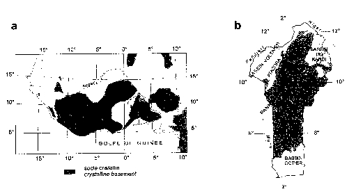
Figure 1: Location of crystalline basement
in West Africa and Benin
The dominating elements of the coastal basin are the seven major plateaux (Figure 2). They are separated by large river streams; the Mono river forms the western boundary, the Couffo, Ouémé and in the northern part the Zou river intersect the plateaux from north to south. In east-west direction the plateaux are separated by the central depression. The southern plateaux are very even. They drop gently from their northern fringe (160 m NN) to the south (20-40 m NN) where they are bordered by a former erosive coastline and a level littoral belt that extends 4 - 10 km along the coast line. Medium slopes (4 8 % gradient) encircle the plateaux and separate them from the central depression, the valleys and the littoral belt.
Two types of valleys are incised into the plateaux. Narrow valleys with concave slopes drain from north to south. E-W oriented broader valley systems show slopes. Another morphological element on the two south-eastern plateaux are the numerous small depressions without external drainage, almost circular in form and of varying size, mainly in the range of 1 km of diameter. Their origin is not yet clear (Slansky, 1962).
The northern plateaux are a bit more undulating
than their southern counterparts. To the south they are separated by a
softly sloping rise from the central depression. To the north, steep and
medium slopes lead over to the crystalline basement.
The central depression is very flat. It
extends from Togo to Nigeria. The drainage system is not very well developed.
Some parts are frequently flooded due to imperfect external drainage. In
the western part some small hills of calcareous outcrop are found.
The particular geomorphology of Central
Benin is closely linked to lithology and geological history (Berding et
van Diepen, 1982 ; Houndagba, 1984). The landscape is characterised by
peneplains with scattered inselbergs and plateaux; it is crossed in the
south-east by the Couffo river, in the west by the Ouémé
which receives important affluent from the Okpara (NE) and Zou (NW). NS
oriented mountain chains occur at Dassa, Gobada, Logozohe, Tchetti, Savalou,
Lanta, and Badagba. The Dassa and Savalou mountains represent the highest
summits with up to 540 m NN but a medium altitude of 400 m NN. The peneplains
seam to correspond to an old levelling surface (or old pediment) at a medium
altitude of about 200 m. The peneplain itself is composed of two levels
:
- a medium level altitude (120-200 m) with very few marked landforms convex flanks in granitic zones and short concave slopes elsewhere.
- a low level altitude (<120m).
In the west of the basement, the topography
is very gentle. Basement outcrops are very frequent but inselbergs are
rare. In the east, the landscape is formed by hills and the hydraulic network
is dense. In the south, the landscape forms are more pronounced with short
rectilinear glacis. This zone corresponds to the younger part of the crystalline
basement (Volkoff, B. 1969).
In general, the peneplain can be considered
as surrounded by two higher altitude levels:
- the sedimentary plateaux series in the south with more than 200 m and limited by a ledge;
- the mountain range of Savalou in the north.
3.2 Geology
The south of Benin is formed of sediments
deposited over the so-called crystalline basement which inclines with approximately
2 % towards the south. The crystalline basement of Benin is surrounded
by three sedimentary basins: coastal basin (meso-Cenozoique) in the south,
the Kandi basin in the north-east (Palaeozoic) and the Precambrian voltaic
basin in the north-west (Faure et Volkoff, 1996).
(Figure 1). At the coast line the sedimentary layer has a thickness of approximate 2000 m. Figure 3 gives an overview of the stratigraphic arrangement. According to OBEMINES (1989) the following units can be found:
Unit I: Turonien - Coniacien, TC, A layer of 50 to 150 m (at exposure) of quartz sands and sandstones that has been correlated to an offshore sequence of Turonien sandstone directly overlying the crystalline basement. Due to this fact an age of 90 Mio. years has been attributed to it. The deposition has taken place in a coastal environment. This unit forms the northern border of the plateaux.
Unit IIa: Maestrichtien, Ma The main part of the northern plateaux is covered with sediments of this unit. It has formed in a sub-littoral environment with a base of the type barrier island, due to a rapid transgression. The lithology is constituted of fine quartz sand with kaolinitic grey to green clays. The thickness of the sediments is variable with a maximum of 180 m.
Unit IIb: Paleocene inferior - middle,
Pim The unit IIb is divided from IIa by a compacted glauconithic
- oolithic cut due to the drop of the sea level at the transition from
Maestrichtien to Paleocene . This unit has formed under the same conditions
and with the same lithology as unit IIa. It covers the northern part of
the central depression. The thickness is very constant with approximately
50 m.
Table 1: Stratigraphy
of geological sediments in southern Benin, comparisons of data OBEMINES
(1989) and Slansky (1962)
| Period | Epoque | Age | Ma | Unit | (Slansky, 1962) |
| Quaternary | 03 | VIII | Alluviums | ||
| Tertiary | Pliocence | VII | Continental | ||
| Miocene | Tortonien | » 10 | VI | Terminal | |
| Burdigalein | » 20 | V | |||
| Aquitanien | |||||
| Eocene | Bartonien | » 40 | IV | Lutetien | |
| Lutetien | |||||
| Ypresion | » 50 | IIIb | Ypresien | ||
| Paleocene | Thanetien | » 53 - 60 | IIIa | Paleoc. Sup. | |
| Danien | » 60 - 65 | Iib | Paleoc. Inf. | ||
| Cretacean | Superior | Maestrichtien | » 70 | Iia | Maestrichtien |
| Coniacien | |||||
| Turonien | » 90 | I | Missing |
Unit III: Paleocene superior - Ypresien, Ps The center of the central depression is covered mainly by sediments of this unit. It has been subdivided due to a glauconithic layer that corresponds to the maximum of the marine level at the transition from Paleocene to Eocene age. Deposited in a external sublitoral environment the unit IIIa (Paleocene superior) is formed by dark grey clays and marl. The content of attapulgite and kaolinite is variable. The highest attapulgite content is found at the base.
Unit IIIb (Ypresien) is made up of greenish clays, dominated by attapulgite. Calcaric and phosphatated layers appear frequently. The conditions of formation were the same as for unit IIIa, only a bit less anoxic. Unit III has a maximum thickness of 155 m.
Unit IV: middle Eocene, Em The southern part of the central depression is covered with sediments of the middle Eocene with a maximum thickness of 170 m.
It is formed of grey-greenish attapulgite clays with shallow layers of bio-clastic wackestones. Shell layers and sandy-silty pockets indicate a more internal sub-litoral formation.
Unit V: Lower Miocene This unit has only been detected in drills.
Unit VI: Upper Miocene, Ms The southern plateaux are entirely build up by this unit. It has formed in a changing environment under coastal conditions.Cycles of barrier island formation and continental deposition form interstrata with marine formations. This indicates propagation of the coast line during that age. Due to these facts the annotation 'Continental terminale' given to that formation (Slansky, 1962) has been dropped. The surface formations of this unit are mainly sandy clays, in some cases iron-indurated sand/claystone.
Unit VII: Pliocene - Pleistocene During this period only shallow fluviatile deposits can be detected in various parts of the area, mainly at the southern borders of the plateaux and oriented towards the large valley systems. They mainly show gravelly deposits with sandy clays.
Unit VIII: Quaternary Quaternary deposits
are found at the coastal belt and in the river systems. They can have considerable
depths, e.g. up to 100 m in the Ouémé valley. The low sea
level during the glacial period has lead to deeply incised valleys that
have been refilled with sandy and clayey Holocene sediments. The coastal
belt has formed under the influence of several changes of the sea level.
During the transgression of the Inchirien a raised sea level has formed
a cliff coast in the Upper Miocene. The cycles of rise and set of the sea
level during the glaciary period has formed a coast with barrier islands
of different ages with lagoon valleys and tidal sandy deposits.
The crystalline basement consists of two blocs: an eastern one mainly composed of migmatite and granite and a western one composed of gneiss and granulite (Aicard, 1957; Pougnet, 1957).
The Precambrian crystalline rocks are usually
known a basement complex. Petrographically, they are largely composed
of acid metamorphic rocks of the Dahomeyen series (gneiss, quartzite,
migmatite). Included are granites and basic intrusive gabbro as well (Pougnet,
1957; Aicard, 1957; BRGM, 1960; Aicard and Pougnet, 1952). According to
OBEMINES (1989) the area has three groups of morphostructural units: the
proterozoic, granitoid and metamorphic complex.
The Proterozoic is composed of three series :
- The Lanta series is a sedimentary series of volcano-clastics which appears at the surface and covers 5 km². Lithology is characterised by sandstones and microconglomerate with quartz pebbles.
- The Daho-Maho series appears at the surface between Ouémé river and Fita in the north of the study area. They extend 100 km long and 10 km wide and are composed of volcanic rocks rhyolite, microgranite, alkaline granite and basalt.
- The Ouédo series is composed of volcanic acid rocks and occur around Setto between the Ouedo and Zou rivers.
The metamorphic complex
This group contains a wide of variety
of rock types. Migmatites (mgn) cover more than 60 % of the study area
and show a great variety of morphologies. This unit includes gneiss with
biotite and amphibole, amphibolites and gneiss with granite which is characterised
by intensive migmatisation. The amphibolites are sometimes characterised
by leucosomatic material which shows agmatitic structure. One mylonitic
zone crosses the migmatite (NE direction) in the extreme south-east of
the crystalline socle.
A Rb/Sr age was determined by IRB (1985) on migmatitic gneiss from two samples of the Dassa-Zoumè zone. The determined age is 916 ± 65 Ma. This value may indicate the age of the metamorphic event linked to the migmatisation. The conventional age determined by Bonhomme (1962) on a gneiss sample from Savè is on the contrary 528 ± 16 Ma.
Gneiss eye-agate with biotite and with amphibole (gno). This unit consists of orthogneiss normally associated to migmatite. The rocks form elongated mountains with abrupt slopes.
Granites - Two types of granite exist: porphyric granite and granite with biotite.
Porphyric granites are constituted by potassic feldspars, quartz, red biotite and plagioclase.
Granites with biotite are located in the western part and appear at the surface in Agouna, Tchetty, Adanhoue. They form small hills. In some places they are affected by metamorphic deformations which create foliated levels with eye-agate structure. That is the case of the Tré granite around Dassa-Zoumè, placed in the eye-agate gneiss.
Gneiss with amphibole and biotite, (gnab) These rocks form a long strip in the central western part of the basement and consist principally by gneiss layered with amphibolites and biotite, with nodules of amphibolites and pyroxenites.
Within the metamorphic complex additionaly occur amphibolites, alkaline gneiss with pyroxene (gnp), quartzite (Q), marble (M), gneiss with biotite and hyperstene (gngr) granulites (gr), charnockites gabbroites (ch-gb), agmatitic metagabbros (gnd), blastomylonites and mylonites (my).
The most distinctive sedimentary basin
and basement complex rock types are depicted on a separate map (Figure
4), and a geological cross-section (Agouna/Zou and Agbado rivers/Dassa-zoumé/Ouémé
and Okpara rivers) is given in figure 5. The symbols correspond to the
ones on the geological map legend.
The geomorphology of the southern study area is characterised by seven major plateaux separated by large river streams and the central Lama depression. In the north of these plateaux, the landscape is a peneplain with scattered inselbergs, plateaux and shallow valleys.
The plateaux are formed of sediments deposited over the crystalline socle. These sediments belong to the Quaternary, Tertiary and Cretaceous period. The southern crystalline basement of Benin can be considered as a portion of the continental crust with intermediate depth, composed by meta-sedimentary series (quartzite, marble and partly gneiss) associated with granite of different ages. According to Bigioggero et al. (1988), the granites belong to different geological periods. In fact, porphyric granites (yo), eye-agate granitic gneiss (gno) and granites with biotite (y) show a distribution of typical elements of the anatectic granites derived from a continental crust.
On the contrary, the granite of Lanta and Gobada, and particularly the granite of Fita, are characterised by a high share of Nb and Y and by a low Rb/Nb+Y ratio, which suggests an origin (magma with alkaline tendency) in greater depth.
Although it is crossed by mylonitic bands
of regional importance, the basement appears uniform without remarkable
variations of the lithologic, metamorphic and tectonic characteristics.
AICARD P., 1957 : Le précambien du Togo et du Nord-Ouest du Dahomey. Bull. dir. Fédér. Min. Géol. Affr. Occ. Fr. Dakar 23, 226 p.6 Further ReadingsAICARD, P. and POUGNET R., 1952 : Le Dahomeyen du Dahomey et du Togo francais. Congrès Géol. Intern. Alger Assoc. Serv. Géol. Afr., A.S.G.A:, XX. 107-113.
BERDING, F. et Van DIEPEN C.A., 1982. Notice explicative des cartes daptitude culturale de la R. P. du Bénin. Etude n° 251 CENAP/Cotonou
BIGIOGGERO, B.et al. 1988: Données préliminaires sur les granites du Bénin méridional. Rendiconti SIMP Vol. 43 n° 1
BONHOMME, M. 1962: Contribution à l´étude géochronologique de la plate-forme de l´Ouest africain. Ann. Fac. Sc. Univ. Clermont, Géol. Min. , 5ème fasc. , 1962. (thèse Clermont Ferrand).
BRGM, 1960 : Carte géologique de la république du Dahomey (Bénin) á 1/1000.000 OBEMINES Cotonou.
FAO, 1993: Global and National Soil and Terrain Digital Database (SOTER). Procedures manual. World Soil Resources Reports No. 74 FAO. Rome. Italy.
FAURE, P. and B. Volkoff, 1996: Différenciation régionale des couvertures pédologiques et litho-geomorphologie sur socle granito-gneissique du Bénin (Afrique Occidentale). C. R. Acad. Sci. Paris t. 322, série IIa , p. 393-400.
HOUNDAGBA C.J., 1984 : Analyse typologique des paysages dAbomey-Zagnanado en R.P. du Bénin. Thèse 3e cycle Université Louis Pasteur Strasbourg. 286p.
IGN 1954: Cartes topographiques du Bénin au 1:50.000. Feuilles Sud Benin. IGN Cotonou, IGN Paris.
IGN 1963: Cartes topographiques du Bénin. Au 1:50.000. Feuilles Centre Benin. IGN Cotonou, IGN Paris.
IRB, 1985: Etude de la cartographie géologique et prospection minière de reconnaissance au sud du 9ème paralléle. Rapport du Projet F:E:D: N° 5100.11.13.015, p.111
OBEMINES, 1989: Carte géologique du Bénin à 1:200 000. Office Béninoise des Mines. Cotonou, Bénin.
POUGNET, R. 1957: Le precambien du Dahomey. Bulletin n° 22 de la D. F. du Min. et de la géographie Afrique Occidentale Francaise. Dakar, n°22.
SLANSKY, M. 1962: Contribution à l´étude du bassin sédimentaire côtier du Dahomey et du Togo. Mem. Bur. Rech. Géol. Min.
VOLKOFF B. (1969). Carte pédologique de reconnaissance de la République Populaire du Bénin. Feuille Dassa-Zoumè (Socle cristallin). ORSTOM, Paris. 63p.
LEVEQUE, A. 1979: Pedogenèse sur socle granito-gneissique du Togo. Differenciation des sols et remaniements superficiels. Travaux et documents de l´ORSTOM, n° 108, Paris, 224 p.7 Related Websites
Figure 2: Digital elevation model of southern Benin
Map1 : Geology
of southern Benin
Includes the following data (if available) compressed into one "zip" file:
- GIS: layers (ArcView, *.shp), projects (ArcView project files, *.apr) and legends (ArcView legends *.avl)
- source data: tab delimited text (*.txt), excel5 (*.xls), rich text format (*.rtf)
metadata: text file (*.txt)